The Himalayas (also Himalaya, Hindi: हिमालय, IPA pronunciation: [hɪ'mɑlijə], [ˌhɪmə'leɪjə]) are a mountain range in Asia, separating the Indian subcontinent from the Tibetan Plateau. By extension, it is also the name of the massive mountain system which includes the Himalaya proper, the Karakoram, the Hindu Kush, and a host of minor ranges extending from the Pamir Knot. The name is from Sanskrit himālaya, a tatpurusa compound meaning "the abode of snow" (from hima "snow", and ālaya "abode"; see also Himavat).[1]
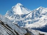
Together, the Himalaya mountain system is the planet's highest and home to the world's highest peaks: the Eight-thousanders, including Mount Everest. To comprehend the enormous scale of Himalayan peaks, consider that Aconcagua, in the Andes, at 6,962 m, is the highest peak outside the Himalaya, while the Himalayan system has over 100 separate mountains exceeding 7,200 meters.[2]
The Himalayas stretch across six nations: Bhutan, China, India, Nepal, Pakistan and Afghanistan. They are the source of three of the world's major river systems, the Indus basin, the Ganga-Brahmaputra basin and the Yangtze basin. Approximately 2.4 billion people live in the drainage basin of the Himalayan rivers, among them the people of Bangladesh. The Himalayas run, west to east, from the Indus river valley to the Brahmaputra river valley, thereby forming an arc 2,400 km long, which varies in width from 400 km in the western Kashmir-Xinjiang region to 150 km in the eastern Tibet-Arunachal Pradesh region. The Himalaya chain consists of three parallel ranges, with the northern-most range known as the Great or Inner Himalayas.
Contents[hide]
1 Ecology
1.1 Lowland forests
1.2 The Terai belt
1.3 Bhabhar belt
1.4 Siwalik Hills
1.5 Inner Terai or Dun Valleys
1.6 Lesser Himalaya
1.7 Midlands
1.8 Alpine shrub and grasslands
2 Origins and growth
3 Glaciers and river systems
4 Lakes
5 Impact on climate
6 Mountain passes
7 Impact on politics and culture
8 Himal
9 Notable peaks
10 Notable Himalayan mountaineers
11 Religion
12 The Himalayas in fiction
13 See also
14 Notes
15 References
16 Further reading
17 External links
//
[edit] Ecology
The flora and fauna of the Himalayas varies with climate, rainfall, altitude, and soils. The climate ranges from tropical at the base of the mountains to permanent ice and snow at the highest elevations. The amount of yearly rainfall increases from west to east along the front of the range. This diversity of climate, altitude, rainfall and soil conditions generates a variety of distinct plant and animal communities, or ecoregions.
[edit] Lowland forests
On the Indo-Gangetic plain at the base of the mountains, an alluvial plain drained by the Indus and Ganga-Brahmaputra river systems, vegetation varies from west to east with rainfall. The xeric Northwestern thorn scrub forests occupy the plains of Pakistan and the Indian Punjab. Further east lie the Upper Gangetic plains moist deciduous forests of Uttar Pradesh and Lower Gangetic plains moist deciduous forests of Bihar and West Bengal. These are monsoon forests, with drought-deciduous trees that lose their leaves during the dry season. The moister Brahmaputra Valley semi-evergreen forests occupy the plains of Assam.
[edit] The Terai belt
Above the alluvial plain lies the Terai strip, a seasonally marshy zone of sand and clay soils. The Terai has higher rainfall than the plains, and the downward-rushing rivers of the Himalaya slow down and spread out in the flatter Terai zone, depositing fertile silt during the monsoon season and receding in the dry season. The Terai has a high water table due to groundwater percolating down from the adjacent bhabhar zone. The central part of the Terai belt is occupied by the Terai-Duar savanna and grasslands, a mosaic of grasslands, savannas, deciduous and evergreen forests that includes some of the world's tallest grasslands. The grasslands of the Terai belt are home to the Indian Rhinoceros (Rhinoceros unicornis).
[edit] Bhabhar belt
Above the Terai belt is an upland zone known as the Bhabhar, a zone of porous and rocky soils, made up of debris washed down from the higher ranges. The Bhabhar and the lower Siwalik ranges have a subtropical climate. The Himalayan subtropical pine forests occupy the western end of the subtropical belt, with forests dominated by Chir Pine (Pinus roxburghii). The central part of the range is home to the Himalayan subtropical broadleaf forests, dominated by sal (Shorea robusta).
[edit] Siwalik Hills
Also called Churia Hills. Intermittent outermost range of foothills extending across Himalayan region through Pakistan, India, Nepal and Bhutan. Consists of many sub-ranges. Summits generally 600 to 1,200 meters. Steeper southern slopes form along a fault zone called Main Frontal Thrust; northern slopes are gentler. Permeable conglomerates and other rocks allow rainwater to percolate downslope into the Bhabhar and Terai, supporting only scrubby forests upslope.
[edit] Inner Terai or Dun Valleys
Open valleys north of Siwalik Hills or nestled between Siwalik subranges. Examples include Dehra Dun in India and Chitwan in Nepal.
[edit] Lesser Himalaya
Prominent range 2,000 to 3,000 meters high forming along the Main Boundary Thrust fault zone with a steep southern face and gentler northern slopes. Nearly continuous except for river gorges. Rivers gather in candelabra form to the north to break through this range in relatively few places.
[edit] Midlands
'Hilly' region averaging about 1,000 meters immediately north of the Mahabharat Range, rising over about 100 km to about 4,000 meters at the Main Frontal Thrust fault zone where the Greater Himalaya begin.
Montane forests - At the middle elevations of the range, the subtropical forests yield to a belt of temperate broadleaf and mixed forests, with the Western Himalayan broadleaf forests at the western end of the range, and the Eastern Himalayan broadleaf forests in Assam and Arunachal Pradesh. Above the broadleaf forests are the Western and Eastern Himalayan subalpine conifer forests.
[edit] Alpine shrub and grasslands
Shilla (7026 m) above the Spiti Valley in India
Above the tree line are the Northwestern, Western, and Eastern Himalayan alpine shrub and meadows, which yield to tundra in the higher Himalayan range. The alpine meadows are the summer habitat of the endangered Snow Leopard (Uncia uncia).
[edit] Origins and growth
The 6,000 km plus journey of the India landmass (Indian Plate) before its collision with Asia (Eurasian Plate) about 40 to 50 million years ago.
Main article: Geology of the Himalaya